| We hear about the Israeli settlements but there has not been any coherent reporting on just how the settlements fit into Israeli plans. This is a series of articles that shows how the Israelis have planned against the formation of a Palestinian state. They show clearly that the Israelis have never intended to end the occupation but only intend to continually strangle the Palestinians. These articles show, in graphic and pictorial detail, why Arafat was right to turn Barak down.
The Politics of Verticality
by Eyal Weizman
None of us have a coherent mental map of the Israeli-Palestinian conflict. Architect Eyal Weizman explains why. We’re missing verticality. In this series of articles and photo-essays (published daily over a week) he paints the extraordinary, three-dimensional battle over the West Bank: from settlements to sewage, archaeology to Apaches.
episode 1: INTRODUCTION
Weizman introduces the experience of territory in the West Bank, which explodes simple political boundaries and “crashes three-dimensional space into six dimensions – three Jewish and three Arab”.
Since the 1967 war, when Israel occupied the West Bank and the Gaza strip, a colossal project of strategic, territorial and architectural planning has lain at the heart of the Israeli-Palestinian conflict.
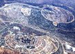
The landscape and the built environment became the arena of conflict. Jewish settlements – state-sponsored islands of ‘territorial and personal democracy’, manifestations of the Zionist pioneering ethos – were placed on hilltops overlooking the dense and rapidly changing fabric of the Palestinian cities and villages. ‘First’ and ‘Third’ Worlds spread out in a fragmented patchwork: a territorial ecosystem of externally alienated, internally homogenised enclaves located next to, within, above or below each other.
New and intricate frontiers were invented, like the temporary borders later drawn up in the Oslo Interim Accord, under which the Palestinian Authority was given control over isolated territorial ‘islands’, but Israel retained control over the airspace above them and the sub-terrain beneath.
This process might be described as the ‘politics of verticality’. It began as a set of ideas, policies, projects and regulations proposed by Israeli state- technocrats, generals, archaeologists, planners and road engineers since the occupation of the West Bank, severing the territory into different, discontinuous layers.
A new understanding of territory had to be developed to govern the West Bank. The Occupied Territories were no longer seen as a two-dimensional surface, but as a large three-dimensional volume, layered with strategic, religious and political strata.
episode 2: MAPS
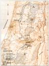
Two-dimensional maps, fundamental to the understanding of political borders, have been drawn again and again for the West Bank. Each time they have failed to capture its vertical divisions.
episode 3: HILLS AND VALLEYS OF THE WEST BANK

Mountains play a special part in Zionist holiness. The settlers’ surge into the folded terrain of the West Bank and up to its summits combines imperatives of politics and spirituality.
Six more articles to come.
----------
An excellent compendium of articles on the Palestinian-Israeli Conflict
Research Guide to the Palestinian-Israeli Conflict
thanks to BookNotes |