| map art
This is one of the most amazing things I've seen on the web. David Rumsey has a lot of money. He really loves maps. He takes his money and his maps (and now other maps) and makes them freely available on the web in a *very* useful way.
In Vintage Maps, a Japan Bygone Floats Lyrically Online
FOR half a century, a rare and extensive collection of historical Japanese maps spanning hundreds of years have been stored in the East Asian Library at the University of California, revealing their secrets only to those few who had received permission to handle them. Now, through state-of-the-art imaging technology, anyone can view these fragile maps online, at www.davidrumsey.com/japan.
So far, 210 maps - some dating back almost 400 years - from the 2,300-piece collection are online. The collection, which will be available for viewing in its entirety within two years, includes 252 maps of the city of Edo (now Tokyo), 79 maps of Kyoto and 40 maps of Osaka spanning the years 1600 to 1867. Many are woodblock prints on handmade paper. The collection also includes a map from 1710 depicting the center of the world as the source of four great rivers of India, and a 40-foot scroll map of the roads of Japan in 1687.
Visitors to the Web site can save the maps for their own collections; analyze, rotate, enlarge and crop them; and compare them with modern maps.
[more]
thanks to wood s lot
Japanese Historical Maps
The Japanese Historical Map Collection contains about 2,300 early maps of Japan and the World. The collection was acquired by the University of California from the Mitsui family in 1949, and is housed on the Berkeley campus in the East Asian Library. Represented in this online collection are about 100 maps and books from this Collection. The maps were selected by Yuki Ishimatsu, Head of Japanese Collections at the East Asian Library, and scanned and put online by David Rumsey and Cartography Associates. The project was initiated by Peter Zhou, Director of the East Asian Library. Funding and project management is provided by Cartography Associates and the East Asian Library.
[more]
thanks to wood s lot
Here are a couple of screen shots showing a complete map and how far you can zoom in to see detail. All these maps are works of art and can be studied in detail. Many, many, many, many thanks are due to David Rumsey for sharing this beauty.
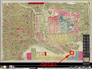
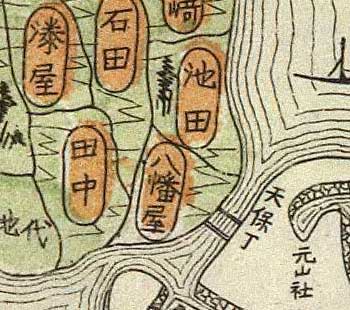
[Update: The viewing software allows you to download the images at *high* resolutions! The above image downloaded, at the highest resolution (there are nine choices), a 16.5mb jpeg. That expanded to 154mb in Photoshop.]
|